Wednesday, December 30, 2009

Cassini Spacecraft to Monitor North Pole on Titan

Artist concept of NASA's Cassini spacecraft flying by the north polar region of Saturn's moon Titan on Dec. 27Though there are no plans to investigate whether Saturn's moon Titan has a Santa Claus, NASA's Cassini will zoom close to Titan's north pole this weekend.

The flyby, which brings Cassini to within about 960 kilometers (600 miles) of the Titan surface at 82 degrees north latitude, will take place the evening of Dec. 27 Pacific time, or shortly after midnight Universal Time on Dec. 28.

The encounter will enable scientists to gather more detail on how the lake-dotted north polar region of Titan changes with the seasons. Scientists will be using high-resolution radar to scan the large and numerous lakes in the north polar region for shape-shifting in size and depth. The ion and neutral mass spectrometer team will take baseline measurements of the atmosphere to compare with the moon's south polar region when Cassini flies by that area on Jan. 12. Cassini will also be collecting images for a mosaic of a bright region called Adiri, where the Huygens probe landed nearly five years ago.

Cassini will have released the Huygens probe exactly five years and three days before this latest flyby. Huygens began its journey down to Titan on the evening of Dec. 24, 2004 California time, or early Dec. 25 Universal Time, and reached the surface Jan. 14, 2005.

Cassini last flew by Titan on Dec. 11, 2009 California time, or Dec. 12 Universal Time. Although this latest flyby is dubbed "T64," planning changes early in the orbital tour have made this the 65th targeted flyby of Titan.


View this site auto transport

Sunday, December 27, 2009

Passing of Stan Lebar

Stan Lebar, who led the Westinghouse Electric Corporation team that developed the lunar camera that brought the televised news images of Neil Armstrong stepping onto the moon to more than 500 million people on earth, died on Tuesday, Dec. 22, 2009.

Stan Lebar next to an image of him with the lunar cameraDuring his long and distinguished career, other camera programs he managed for NASA included the Apollo Color TV Cameras, the Skylab series of TV cameras, and the TV cameras for the Apollo-Soyuz Test Program (ASTP).

From 1943 until the end of World War II, Lebar served in the Pacific Theater of Operations as an Air Force B-24 Ball Turret Gunner. After the war, he attended the University of Missouri and received a BS in Electrical Engineering in 1950. He joined Westinghouse Electric Corporation in 1953, and worked in the Aerospace Division, Baltimore, Maryland, until his retirement in 1986.


View this site auto transport

Thursday, December 24, 2009

AcrimSat Celebrates 10 Years of Measuring the Sun's Energy

AcrimSatLaunched Dec. 20, 1999, the Active Cavity Radiometer Irradiance Monitor Satellite (AcrimSat) monitors the total amount of the sun's energy reaching Earth. It is this energy, called total solar irradiance, that creates the winds, heats the land and drives ocean currents. Some scientists theorize a significant fraction of Earth's warming may be solar in origin due to small increases in the sun's total energy output since the last century. By measuring incoming solar radiation, climatologists are using AcrimSat to improve their predictions of climate change and global warming over the next century.

For more information on AcrimSat, see: http://acrim.jpl.nasa.gov/.


View this site auto transport

Tuesday, December 22, 2009

Mock and Roll! NASA's Shuttle Endeavour Moves to Launch Pad, Liftoff Dress Rehearsal Set

Journalists are invited to cover space shuttle Endeavour's move from the Vehicle Assembly Building to Launch Pad 39A on Jan. 6 and observe the STS-130 crew's mock launch countdown activities from Jan. 19 to Jan. 21 at NASA's Kennedy Space Center in Florida.

The first motion of Endeavour on its rollout to the pad is scheduled for 4 a.m. EST. The 3.4-mile journey is expected to take approximately six hours. Activities include a 7 a.m. photo opportunity of the shuttle's move, followed by an 8:30 a.m. interview availability with Endeavour Flow Director Dana Hutcherson. Reporters must arrive at Kennedy's news center by 6:30 a.m. on Wednesday for transportation to the viewing area.

Live coverage of the move will be shown on NASA Television beginning at 6 a.m. Video highlights will air on the NASA TV Video File.

Foreign journalist media accreditation for rollout is closed. U.S. reporters without permanent Kennedy credentials must apply for accreditation by 4 p.m. Monday, Jan. 4.

Endeavour's astronauts and ground crews will participate in a launch dress rehearsal, known as the Terminal Countdown Demonstration Test, starting Jan. 19. The test provides each shuttle crew with an opportunity to participate in various simulated countdown activities, including equipment familiarization and emergency training. Media events associated with the test and badge pick up information will be announced at a later date.

Journalists must apply for accreditation for the Terminal Countdown Demonstration Test by noon on Friday, Jan. 8.

Reporters requesting accreditation must apply online at:

https://media.ksc.nasa.gov

Badges for rollout must be picked up before 4 p.m. on Tuesday, Jan. 5, at the Kennedy Space Center Badging Office on State Road 405.

The six astronauts for Endeavour's STS-130 mission will deliver a third connecting module, the Tranquility node, to the International Space Station. Launch is targeted for 4:39 a.m. Feb. 7.

For NASA TV downlink information, schedules and links to streaming video, visit:

http://www.nasa.gov/ntv

For more information about the STS-130 mission and crew, visit:

http://www.nasa.gov/shuttle


View this site auto transport

Monday, December 21, 2009

Sunlight Glint Confirms Liquid in Titan Lake Zone

Reflection of sunlight off Titan lake
NASA's Cassini Spacecraft has captured the first flash of sunlight reflected off a lake on Saturn's moon Titan, confirming the presence of liquid on the part of the moon dotted with many large, lake-shaped basins.

Cassini scientists had been looking for the glint, also known as a specular reflection, since the spacecraft began orbiting Saturn in 2004. But Titan's northern hemisphere, which has more lakes than the southern hemisphere, has been veiled in winter darkness. The sun only began to directly illuminate the northern lakes recently as it approached the equinox of August 2009, the start of spring in the northern hemisphere. Titan's hazy atmosphere also blocked out reflections of sunlight in most wavelengths. This serendipitous image was captured on July 8, 2009, using Cassini's visual and infrared mapping spectrometer.

The new infrared image is available online at: http://www.nasa.gov/cassini, http://saturn.jpl.nasa.gov and http://wwwvims.lpl.arizona.edu.

This image will be presented Friday, Dec. 18, at the fall meeting of the American Geophysical Union in San Francisco.

"This one image communicates so much about Titan -- thick atmosphere, surface lakes and an otherworldliness," said Bob Pappalardo, Cassini project scientist, based at NASA's Jet Propulsion Laboratory, Pasadena, Calif. "It's an unsettling combination of strangeness yet similarity to Earth. This picture is one of Cassini's iconic images."

Titan, Saturn's largest moon, has captivated scientists because of its many similarities to Earth. Scientists have theorized for 20 years that Titan's cold surface hosts seas or lakes of liquid hydrocarbons, making it the only other planetary body besides Earth believed to harbor liquid on its surface. While data from Cassini have not indicated any vast seas, they have revealed large lakes near Titan's north and south poles.

In 2008, Cassini scientists using infrared data confirmed the presence of liquid in Ontario Lacus, the largest lake in Titan's southern hemisphere. But they were still looking for the smoking gun to confirm liquid in the northern hemisphere, where lakes are also larger.

Katrin Stephan, of the German Aerospace Center (DLR) in Berlin, an associate member of the Cassini visual and infrared mapping spectrometer team, was processing the initial image and was the first to see the glint on July 10th.

"I was instantly excited because the glint reminded me of an image of our own planet taken from orbit around Earth, showing a reflection of sunlight on an ocean," Stephan said. "But we also had to do more work to make sure the glint we were seeing wasn't lightning or an erupting volcano."

Team members at the University of Arizona, Tucson, processed the image further, and scientists were able to compare the new image to radar and near-infrared-light images acquired from 2006 to 2008.

They were able to correlate the reflection to the southern shoreline of a lake called Kraken Mare. The sprawling Kraken Mare covers about 400,000 square kilometers (150,000 square miles), an area larger than the Caspian Sea, the largest lake on Earth. It is located around 71 degrees north latitude and 337 degrees west latitude.

The finding shows that the shoreline of Kraken Mare has been stable over the last three years and that Titan has an ongoing hydrological cycle that brings liquids to the surface, said Ralf Jaumann, a visual and infrared mapping spectrometer team member who leads the scientists at the DLR who work on Cassini. Of course, in this case, the liquid in the hydrological cycle is methane rather than water, as it is on Earth.

"These results remind us how unique Titan is in the solar system," Jaumann said. "But they also show us that liquid has a universal power to shape geological surfaces in the same way, no matter what the liquid is."

The Cassini-Huygens mission is a cooperative project of NASA, the European Space Agency and the Italian Space Agency. JPL manages the mission for NASA's Science Mission Directorate, Washington, D.C. The Cassini orbiter was designed, developed and assembled at JPL. The visual and infrared mapping spectrometer team is based at the University of Arizona, Tucson.


View this site auto transport

Saturday, December 19, 2009

Quiet Sun Means Cooling of Earth's Upper Atmosphere

Data from the TIMED (Thermosphere Ionosphere Mesosphere Energetics and Dynamics) mission are being used to understand the climate of the upper atmosphereNew measurements from a NASA satellite show a dramatic cooling in the upper atmosphere that correlates with the declining phase of the current solar cycle. For the first time, researchers can show a timely link between the Sun and the climate of Earth’s thermosphere, the region above 100 km, an essential step in making accurate predictions of climate change in the high atmosphere.

Scientists from NASA's Langley Research Center and Hampton University in Hampton, Va., and the National Center for Atmospheric Research in Boulder, Colo., presented these results at the fall meeting of the American Geophysical Union in San Francisco from Dec. 14 to 18.

Earth's thermosphere and mesosphere have been the least explored regions of the atmosphere. The NASA Thermosphere-Ionosphere-Mesosphere Energetics and Dynamics (TIMED) mission was developed to explore the Earth’s atmosphere above 60 km altitude and was launched in December 2001. One of four instruments on the TIMED mission, the Sounding of the Atmosphere using Broadband Emission Radiometry (SABER) instrument, was specifically designed to measure the energy budget of the mesosphere and lower thermosphere. The SABER dataset now covers eight years of data and has already provided some basic insight into the heat budget of the thermosphere on a variety of timescales.

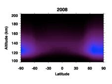
Energy emitted by the upper atmosphere as infrared (IR) radiation in 2002 (top) and 2008 (bottom) -- In this SABER plot, Nitric Oxide (NO) is the IR emitterThe extent of current solar minimum conditions has created a unique situation for recent SABER datasets, explains Stan Solomon, acting director of the High Altitude Observatory, National Center for Atmospheric Research in Boulder, Colo. The end of solar cycle 23 has offered an opportunity to study the radiative cooling in the thermosphere under exceptionally quiescent conditions.

"The Sun is in a very unusual period," said Marty Mlynczak, SABER associate principal investigator and senior research scientist at NASA Langley. "The Earth’s thermosphere is responding remarkably — up to an order of magnitude decrease in infrared emission/radiative cooling by some molecules."

The TIMED measurements show a decrease in the amount of ultraviolet radiation emitted by the Sun. In addition, the amount of infrared radiation emitted from the upper atmosphere by nitric oxide molecules has decreased by nearly a factor of 10 since early 2002. These observations imply that the upper atmosphere has cooled substantially since then. The research team expects the atmosphere to heat up again as solar activity starts to pick up in the next year.

While this warming has no implications for climate change in the troposphere, a fundamental prediction of climate change theory is that the upper atmosphere will cool in response to increasing carbon dioxide. As the atmosphere cools the density will increase, which ultimately may impact satellite operations through increased drag over time.

The SABER dataset is the first global, long-term, and continuous record of the Nitric oxide (NO) and Carbon dioxide (CO2) emissions from the thermosphere.

"We suggest that the dataset of radiative cooling of the thermosphere by NO and CO2 constitutes a first climate data record for the thermosphere," says Mlynczak.

The TIMED data provide a climate record for validation of upper atmosphere climate models, which is an essential step in making accurate predictions of climate change in the high atmosphere. SABER provides the first long-term measurements of natural variability in key terms of the upper atmosphere climate.

"A fundamental prediction of climate change theory is that upper atmosphere will cool in response to greenhouse gases in the troposphere," says Mlynczak. "Scientists need to validate that theory. This climate record of the upper atmosphere is our first chance to have the other side of the equation."

James Russell III, SABER principal investigator and co-director of the Center for Atmospheric Sciences at Hampton University in Hampton, Va., agrees adding, "The atmosphere is a coupled system. If you pick up one end of the stick, you automatically pick up the other – they're intrinsically linked. To be as accurate as possible, scientists have to understand global change throughout the atmosphere."

As the TIMED mission continues, these data derived from SABER will become important in assessing long term atmospheric changes due to the increase of carbon dioxide in the atmosphere.

TIMED is the first mission in the Solar Terrestrial Probes Program within the Heliophysics Division in NASA's Science Mission Directorate in Washington.

Related Links:
› TIMED Mission
› SABER Instrument


View this site auto transport

Friday, December 18, 2009

The Dark Side of Carbon

As interest in Earth's changing climate heats up, a tiny dark particle is stepping into the limelight: black carbon. Commonly known as soot, black carbon enters the air when fossil fuels and biofuels, such as coal, wood, and diesel are burned. Black carbon is found worldwide, but its presence and impact are particularly strong in Asia.

Black carbon, a short-lived particle, is in perpetual motion across the globe. The Tibetan Plateau's high levels of black carbon likely impact the region's temperature, clouds and monsoon season.


View this site auto transport

Thursday, December 17, 2009

NASA Outlines Recent Greenhouse Gas Research

distribution of mid-tropospheric carbon dioxideResearchers studying carbon dioxide, a leading greenhouse gas and a key driver of global climate change, now have a new tool at their disposal: daily global measurements of carbon dioxide in a key part of our atmosphere. The data are courtesy of the Atmospheric Infrared Sounder (AIRS) instrument on NASA's Aqua spacecraft.

Moustafa Chahine, the instrument's science team leader at NASA's Jet Propulsion Laboratory, Pasadena, Calif., unveiled the new product at a briefing on recent breakthroughs in greenhouse gas, weather and climate research from AIRS at this week's American Geophysical Union meeting in San Francisco. The new data have been extensively validated against both aircraft and ground-based observations. They give users daily and monthly measurements of the concentration and distribution of carbon dioxide in the mid-troposphere--the region of the atmosphere located between 5 and 12 kilometers, or 3 to 7 miles, above Earth's surface, and track its global transport. Users can also access historical AIRS carbon dioxide data spanning the mission's entire seven-plus years in orbit. The product represents the first-ever release of global daily carbon dioxide data that are based solely on observations.

"AIRS provides the highest accuracy and yield of any global carbon dioxide data set available to the research community, now and for the immediate future," said Chahine. "It will help researchers understand how this elusive, long-lived greenhouse gas is distributed and transported, and can be used to develop better models to identify 'sinks,' regions of the Earth system that store carbon dioxide. It's important to study carbon dioxide in all levels of the troposphere."

Chahine said previous AIRS research data have led to some key findings about mid-tropospheric carbon dioxide. For example, the data have shown that, contrary to prior assumptions, carbon dioxide is not well mixed in the troposphere, but is rather "lumpy." Until now, models of carbon dioxide transport have assumed its distribution was uniform.

Carbon dioxide is transported in the mid-troposphere from its sources to its eventual sinks. More carbon dioxide is emitted in the heavily populated northern hemisphere than in its less populated southern counterpart. As a result, the southern hemisphere is a net recipient, or sink, for carbon dioxide from the north. AIRS data have previously shown the complexity of the southern hemisphere's carbon dioxide cycle, revealing a never-before-seen belt of carbon dioxide that circles the globe and is not reflected in transport models.

In another major finding, scientists using AIRS data have removed most of the uncertainty about the role of water vapor in atmospheric models. The data are the strongest observational evidence to date for how water vapor responds to a warming climate.

"AIRS temperature and water vapor observations have corroborated climate model predictions that the warming of our climate produced as carbon dioxide levels rise will be greatly exacerbated -- in fact, more than doubled -- by water vapor," said Andrew Dessler, a climate scientist at Texas A&M University, College Station, Texas.

3-D transport and distribution of water vapor as measured by AIRS from June through November 2005

Dessler explained that most of the warming caused by carbon dioxide does not come directly from carbon dioxide, but from effects known as feedbacks. Water vapor is a particularly important feedback. As the climate warms, the atmosphere becomes more humid. Since water is a greenhouse gas, it serves as a powerful positive feedback to the climate system, amplifying the initial warming. AIRS measurements of water vapor reveal that water greatly amplifies warming caused by increased levels of carbon dioxide. Comparisons of AIRS data with models and re-analyses are in excellent agreement.

"The implication of these studies is that, should greenhouse gas emissions continue on their current course of increase, we are virtually certain to see Earth's climate warm by several degrees Celsius in the next century, unless some strong negative feedback mechanism emerges elsewhere in Earth's climate system," Dessler said.

Originally designed to observe atmospheric temperature and water vapor, AIRS data are already responsible for the greatest improvement to five- to six-day weather forecasts than any other single instrument, said Chahine. JPL scientists have shown a major consequence of global warming will be an increase in the frequency and strength of severe storms. Earlier this year, a team of NASA researchers showed how AIRS can significantly improve tropical cyclone forecasting. The researchers studied deadly Typhoon Nargis in Burma in May 2008. They found the uncertainty in the cyclone's landfall position could have been reduced by a factor of six had more sophisticated AIRS temperature data been used in the forecasts.

AIRS observes and records the global daily distribution of temperature, water vapor, clouds and several atmospheric gases including ozone, methane and carbon monoxide. With the addition of the mid-tropospheric carbon dioxide data set this week, a seven-year digital record is now complete for use by the scientific community and the public.

For more on AIRS, see http://airs.jpl.nasa.gov/ .

JPL is managed for NASA by the California Institute of Technology in Pasadena.

> See all images and animations


View this site auto transport

NASA Outlines Recent Greenhouse Gas Research

distribution of mid-tropospheric carbon dioxideResearchers studying carbon dioxide, a leading greenhouse gas and a key driver of global climate change, now have a new tool at their disposal: daily global measurements of carbon dioxide in a key part of our atmosphere. The data are courtesy of the Atmospheric Infrared Sounder (AIRS) instrument on NASA's Aqua spacecraft.

Moustafa Chahine, the instrument's science team leader at NASA's Jet Propulsion Laboratory, Pasadena, Calif., unveiled the new product at a briefing on recent breakthroughs in greenhouse gas, weather and climate research from AIRS at this week's American Geophysical Union meeting in San Francisco. The new data have been extensively validated against both aircraft and ground-based observations. They give users daily and monthly measurements of the concentration and distribution of carbon dioxide in the mid-troposphere--the region of the atmosphere located between 5 and 12 kilometers, or 3 to 7 miles, above Earth's surface, and track its global transport. Users can also access historical AIRS carbon dioxide data spanning the mission's entire seven-plus years in orbit. The product represents the first-ever release of global daily carbon dioxide data that are based solely on observations.

"AIRS provides the highest accuracy and yield of any global carbon dioxide data set available to the research community, now and for the immediate future," said Chahine. "It will help researchers understand how this elusive, long-lived greenhouse gas is distributed and transported, and can be used to develop better models to identify 'sinks,' regions of the Earth system that store carbon dioxide. It's important to study carbon dioxide in all levels of the troposphere."

Chahine said previous AIRS research data have led to some key findings about mid-tropospheric carbon dioxide. For example, the data have shown that, contrary to prior assumptions, carbon dioxide is not well mixed in the troposphere, but is rather "lumpy." Until now, models of carbon dioxide transport have assumed its distribution was uniform.

Carbon dioxide is transported in the mid-troposphere from its sources to its eventual sinks. More carbon dioxide is emitted in the heavily populated northern hemisphere than in its less populated southern counterpart. As a result, the southern hemisphere is a net recipient, or sink, for carbon dioxide from the north. AIRS data have previously shown the complexity of the southern hemisphere's carbon dioxide cycle, revealing a never-before-seen belt of carbon dioxide that circles the globe and is not reflected in transport models.

In another major finding, scientists using AIRS data have removed most of the uncertainty about the role of water vapor in atmospheric models. The data are the strongest observational evidence to date for how water vapor responds to a warming climate.

"AIRS temperature and water vapor observations have corroborated climate model predictions that the warming of our climate produced as carbon dioxide levels rise will be greatly exacerbated -- in fact, more than doubled -- by water vapor," said Andrew Dessler, a climate scientist at Texas A&M University, College Station, Texas.

3-D transport and distribution of water vapor as measured by AIRS from June through November 2005

Dessler explained that most of the warming caused by carbon dioxide does not come directly from carbon dioxide, but from effects known as feedbacks. Water vapor is a particularly important feedback. As the climate warms, the atmosphere becomes more humid. Since water is a greenhouse gas, it serves as a powerful positive feedback to the climate system, amplifying the initial warming. AIRS measurements of water vapor reveal that water greatly amplifies warming caused by increased levels of carbon dioxide. Comparisons of AIRS data with models and re-analyses are in excellent agreement.

"The implication of these studies is that, should greenhouse gas emissions continue on their current course of increase, we are virtually certain to see Earth's climate warm by several degrees Celsius in the next century, unless some strong negative feedback mechanism emerges elsewhere in Earth's climate system," Dessler said.

Originally designed to observe atmospheric temperature and water vapor, AIRS data are already responsible for the greatest improvement to five- to six-day weather forecasts than any other single instrument, said Chahine. JPL scientists have shown a major consequence of global warming will be an increase in the frequency and strength of severe storms. Earlier this year, a team of NASA researchers showed how AIRS can significantly improve tropical cyclone forecasting. The researchers studied deadly Typhoon Nargis in Burma in May 2008. They found the uncertainty in the cyclone's landfall position could have been reduced by a factor of six had more sophisticated AIRS temperature data been used in the forecasts.

AIRS observes and records the global daily distribution of temperature, water vapor, clouds and several atmospheric gases including ozone, methane and carbon monoxide. With the addition of the mid-tropospheric carbon dioxide data set this week, a seven-year digital record is now complete for use by the scientific community and the public.

For more on AIRS, see http://airs.jpl.nasa.gov/ .

JPL is managed for NASA by the California Institute of Technology in Pasadena.

> See all images and animations

Wednesday, December 16, 2009

Global Digital Elevation Model

Global Digital Elevation Model
This Global Digital Elevation Model, or GDEM, is a product of the Advanced Spaceborne Thermal Emission and Reflection Radiometer (ASTER), a joint program of NASA and Japan's Ministry of Economy, Trade and Industry. The image was released on June 29, 2009, and was created by processing and stereo-correlating the 1.3 million-scene ASTER archive of optical images, covering Earth's land surface between 83 degrees North and 83 degrees South latitudes. The GDEM is produced with 98-feet postings, and is formatted as 23,000 one-by-one-degree tiles. In this colorized version, low elevations are purple, medium elevations are greens and yellows, and high elevations are orange, red and white.

With its 14 spectral bands from the visible to the thermal infrared wavelength region and its high spatial resolution of 50 to 300 feet, ASTER images Earth to map and monitor the changing surface of our planet. ASTER is one of five Earth-observing instruments launched Dec. 18, 1999, on NASA's Terra satellite.

The broad spectral coverage and high spectral resolution of ASTER provides scientists in numerous disciplines with critical information for surface mapping and monitoring of dynamic conditions and temporal change.

Tuesday, December 15, 2009

WISE Lifts Off to Map the Sky

NASA’s Wide-field Infrared Survey Explorer, or WISE, launched aboard a United Launch Alliance Delta II rocket at 9:09 a.m. EST from Space Launch Complex-2 at Vandenberg Air Force Base. WISE will scan the entire sky in infrared light, picking up the glow of hundreds of millions of objects and producing millions of images.

Lifting Off to Study the Sky

Lifting Off to Study the Sky
NASA's Wide-field Infrared Survey Explorer, or WISE, launched aboard a United Launch Alliance Delta II rocket at 9:09 a.m. EST from Space Launch Complex-2 at Vandenberg Air Force Base. WISE will scan the entire sky in infrared light, picking up the glow of hundreds of millions of objects and producing millions of images.

Monday, December 14, 2009

Freezing WISE's Hydrogen

Freezing WISE's Hydrogen
A scaffolding structure built around NASA's Wide-field Infrared Survey Explorer, or WISE, allows engineers to freeze its hydrogen coolant. The WISE infrared instrument is kept extremely cold by a bottle-like tank filled with frozen hydrogen, called the cryostat. The cryostat can be seen at the top of the spacecraft.

Wednesday, December 9, 2009

NASA Earth's Moon

Earth's Moon
During its mission, the Galileo spacecraft returned a number of images of Earth's only natural satellite. Galileo surveyed the moon on Dec. 7, 1992, on its way to explore the Jupiter system in 1995-1997.

This color mosaic was assembled from 18 images taken by Galileo's imaging system through a green filter. On the upperleft is the dark, lava-filled Mare Imbrium, Mare Serenitatis (middle left), Mare Tranquillitatis (lower left), and Mare Crisium, the dark circular feature toward the bottom of the mosaic. Also visible in this view are the dark lava plains of the Marginis and Smythii Basins at the lower right. The Humboldtianum Basin, a 400-mile impact structure partly filled with dark volcanic deposits, is seen at the center of the image.

Tuesday, December 8, 2009

NASA and Arab Youth Venture Foundation Launch Student Program

NASA and the Arab Youth Venture Foundation in Dubai, United Arab Emirates (UAE) have partnered to provide three to 12 UAE engineering students each year the opportunity to work with U.S. students, scientists, and engineers on NASA missions. The program's goal is to engage outstanding college students from the UAE in fields of science, technology, engineering and aerospace.

"The space program has a unique ability to inspire students to pursue excellence in disciplines that drive science and technology innovation," said Joyce Winterton, assistant administrator for education at NASA Headquarters in Washington. "With this Space Act Agreement, NASA will engage outstanding students in the UAE to continue their development in the critical skills of science, technology, engineering and mathematics."

Under this program, UAE students will join U.S. students in a research project administered by the Education Associates Program at NASA's Ames Research Center in Mountain View, Calif. UAE student involvement will provide U.S. student participants with valuable experience and knowledge about working together with representatives from other countries. The Education Associates Program anticipates its first group of Education Research Fellows in January 2010. Corporations and government entities in the UAE will sponsor the foundation's activities in full, including costs related to student lodging, housing, and transportation.

"There is much work to be done to promote and deliver inspired science, technology, education, aerospace and math education in the Arab world that is hands-on and conducted in real world settings," said Lisa-Renee LaBonte, chief executive officer of the Arab Youth Venture Foundation. "This groundbreaking program, administered by NASA, will provide select UAE citizens the opportunity to work with NASA scientists, researchers, and engineers on actual NASA missions."

Founded in Ras Al Khaimah, the Arab Youth Venture Foundation is dedicated to imagining and bringing to life initiatives that nurture the innovative spirits and entrepreneurial mindsets of youth aged six to 21 across the Arab world. The foundation's goal is to create activities that develop the next generation of scientific researchers, engineers, inventors, corporate leaders and entrepreneurs.

Since 1998, the Education Associates Program has placed more than 1,500 U.S. students from schools throughout the country in research positions working on NASA missions. Cooperation with the Arab Youth Venture Foundation will provide future U.S. participants in this NASA sponsored program at Ames with valuable cultural exposure and experience in working with their international counterparts.

This new partnership and NASA's many other education programs play a key role in preparing, inspiring, exciting, encouraging, and nurturing students in the critical disciplines of science, technology, engineering and mathematics.

Learn more about NASA's education programs at:

http://www.nasa.gov/education

Monday, December 7, 2009

Moon Work Design Contest Offers NASA Internships to Winners

Talented engineering students who have ideas on how future explorers might live on the moon could find themselves working at NASA as paid interns.

The 2010 NASA Moon Work engineering design challenge seeks to motivate college students by giving them first-hand experience with the process of developing new technologies. To participate in the contest, students will submit their original design for tools or instruments that can help astronauts live and work on the moon. Top-ranked students will be offered a chance to intern with a team from NASA's Exploration Technology Development Program.

The Exploration Technology Development Program develops new technologies that will enable NASA to conduct future human exploration missions while reducing mission risk and cost. The program is maturing near-term technologies to help enable the first flight of the Orion crew exploration vehicle and developing long-lead technologies needed for possible lunar exploration missions.

Winning Moon Work contestants also will have a chance to attend field tests conducted by the Desert Research and Technology Studies Program, managed by NASA's Johnson Space Center in Houston. The program conducts annual tests of new technologies in landscapes that are close analogs of the moon and other harsh space environments.

Students should submit a notice of intent to enter the contest by Dec. 15. Final entries for the Moon Work challenge are due May 15, 2010. All entries must be from students at U.S. colleges or universities. Although non-citizens may be part of a team, only U.S. citizens may win NASA internships or travel awards.

For complete details and to enter the contest, visit:

http://moonwork.larc.nasa.gov

Christopher Newport University in Newport News, Va., manages the student contest for NASA's Exploration Systems Mission Directorate and NASA's Langley Research Center in Hampton, Va.

Through this and NASA's other college and university programs, the agency is developing student skills in science, technology, engineering and mathematics -- disciplines critical to achieving the agency's space exploration missions.

For more information about NASA's education programs, visit:

http://www.nasa.gov/education

Friday, December 4, 2009

King of All He Surveys

Sitting majestically atop a utility pole at NASA's Kennedy Space Center in Florida, a bald eagle is king of all he surveys. Kennedy co-exists with the Merritt Island National Wildlife Refuge, which provides a habitat for 330 species of birds including bald eagles. A variety of other wildlife--117 kinds of fish, 65 types of amphibians and reptiles, 31 different mammals, and 1,045 species of plants--also inhabit the refuge. For information on the refuge, visit http://www.fws.gov/merrittisland/Index.html.

Thursday, December 3, 2009

Honoring Apollo 13's Fred Haise

Honoring Apollo 13's Fred Haise
At a 1 p.m. ceremony on Dec 2, 2009, Administrator Charles Bolden presented NASA's Ambassador of Exploration Award to Apollo 13 astronaut Fred Haise, a Biloxi, Miss., native. The ceremony took place at Biloxi's Gorenflo Elementary School. Pictured from left to right are school principal Tina Thompson, Administrator Bolden, Fred Haise, Biloxi Public School District Superintendent Paul Tisdale and Stennis Space Center Director Gene Goldman.

Wednesday, December 2, 2009

Space Shuttle Crew Returns Home after 11-Day Mission

Space shuttle Atlantis and its crew of seven astronauts ended an 11-day journey of nearly 4.5 million miles with a 9:44 a.m. EST landing Friday at NASA's Kennedy Space Center in Florida.

The mission, designated STS-129, included three spacewalks and the installation of two platforms to the International Space Station's truss, or backbone. The platforms hold large spare parts to sustain station operations after the shuttles are retired. The shuttle crew delivered about 30,000 pounds of replacement parts for systems that provide power to the station, keep it from overheating, and maintain a proper orientation in space.

STS-129 Commander Charlie Hobaugh was joined on Atlantis' STS-129 mission by Pilot Barry Wilmore and Mission Specialists Leland Melvin, Randy Bresnik, Mike Foreman and Bobby Satcher. Atlantis returned with station resident Nicole Stott, who spent 91 days in space. This marks the final time the shuttle is expected to rotate station crew members.

A welcome ceremony for the astronauts will be held Monday, Nov. 30, in Houston. The public is invited to attend the 4 p.m. CST event at Ellington Field's NASA Hangar 990. Highlights from the ceremony will be broadcast on NASA Television's Video File. For NASA TV downlink information, schedules and links to streaming video, visit:

http://www.nasa.gov/ntv

With Atlantis and its crew safely home, the stage is set for launch of shuttle Endeavour on its STS-130 mission, targeted to begin in February. Endeavour will deliver a pressurized module, known as Tranquility, which will provide room for many of the space station's life support systems. Attached to the node is a cupola, a robotic control station with six windows around its sides and another in the center that provides a 360-degree view around the station.

For more about the STS-129 mission and the upcoming STS-130 flight, visit:

http://www.nasa.gov/shuttle

STS-129 crew members Melvin, Satcher and Stott are providing mission updates on Twitter. For their Twitter feeds and other NASA social media Web sites, visit:

http://www.nasa.gov/connect

For information about NASA and agency programs, visit:

http://www.nasa.gov